Blog RSS Feed

Three New Jerusalem Overlays

April 24th, 2007

As previously hinted, the Jerusalem maps KML file (preview) now has three more overlays:

Conder (1876) Tenz (1894) Wilde (1889)

Thanks to The Jewish National & University Library, Shapell Family Digitization Project, Eran Laor Cartographic Collection and The Hebrew University of Jerusalem, Dept. of Geography, Historic Cities Project, for permission to use these images. Their website is full of historical maps of Jerusalem if you want to explore more of Jerusalem or create your own overlays.

Biblical Bodies of Water KML Update

April 18th, 2007

The KML of water bodies in the Bible now includes outlines of nearly all the rivers, lakes, and seas the Bible mentions. Surprisingly, there aren’t that many.

Only a few water bodies remain: most notably, the Mediterranean, Adriatic, and Red Seas. The KML is too big to preview in Google Maps, so here’s an image for you:

Satellite image showing most of the rivers and other water bodies mentioned in the Bible.

Here are the places in the KML:

Bible Atlas: Now Less Annoying

April 13th, 2007

The entries in the Bible atlas now appear on individual alphabetical pages instead of all on one page. (Though the full version is still available.) The many images on the page made it slow to download even on broadband connections.

Go take a look.

OpenBible on BibleWorks (Unofficially)

April 9th, 2007

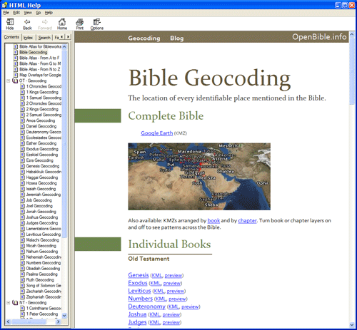
Pasquale on the BibleWorks forum has created a module that lets you browse the maps here directly from BibleWorks (though it helps if you have Google Earth installed). Download the file (35 MB .zip). The forum post has more instructions.

BibleWorks accepts regular HTML Help (.chm) files with some supporting metadata, so it looks like Pasquale created a local version of parts of this website. Nifty! You don’t even need BibleWorks to browse the file itself; any recent Windows computer should work fine. The only disadvantage to a local file, of course, is that it can’t include any new corrections that I make on the site.

I’m linking to a file hosted here here because the file linked on the forum is split into five pieces, which you have to download separately and reassemble. The above link is a simple .zip file.

Passion Week in Google Earth

April 7th, 2007

Download a KML of the locations from the Passion Week in Google Earth or see it on Google Maps.

Passion Week on Google Maps

Passion Week runs from Palm Sunday (Jesus’ triumphal entry into Jerusalem) through Easter Sunday (Jesus’ resurrection). Check out a chronology of Passion Week for more details.

Thanks to Catholic Gauze for the idea.

Virtual Tours with Photosynth

April 4th, 2007

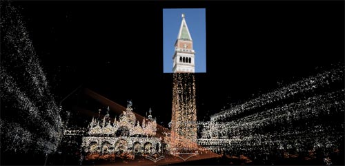
Photosynth is a Microsoft technology preview that creates 3D spaces from a bunch of photographs of the same place. Here’s a screenshot of the application in the space it’s constructed from dozens of photographs of the Piazza San Marco in Venice:

A 3D space showing a photograph of the tower with pointillistic representations of the rest of the piazza.

In the live application you can move around and highlight different photos taken from all sorts of angles. Check out the screencast if you’re hesitant about installing an ActiveX control on your computer.

I can see using this technology to reconstruct highly photographed places like Jerusalem in 3D. It’s not quite as good as building your own virtual-reality model of Jerusalem, but it’s a lot easier. Consider that flickr has about 9200 photos tagged “Jerusalem” under a Creative Commons license, and you can imagine the possibilities.

I look forward to being able to upload your own (or others’) photos and have the application create a space for you. Right now you can only use predefined photo collections.

Via Digital Media Minute.

New KML: Biblical Water Bodies

April 2nd, 2007

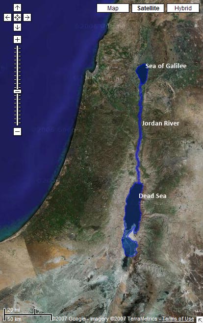
Download a KML with shapes for the Sea of Galilee, the Jordan River, and the Salt (Dead) Sea.

Preview it in Google Maps:

Satellite image from Google Maps with the Sea of Galilee, Jordan River, and Dead Sea highlighted

Limitations

The problem with water data is that water levels and paths fluctuate over time. The path in the KML for the Jordan River matches the current satellite data in Google Earth precisely, for example. But the river will change locations the next time Google updates its satellite imagery. And then I’ll either have to update the path to match the new imagery or live with the discrepancy. Of course, the current path of the Jordan only approximates the path it took in biblical times. So even if I update the file whenever Google gets new data, it still won’t accurately represent the historical context (which is impossible to reconstruct).

Even worse is the Dead Sea, which has dramatically shrunk over the past century as more fresh water gets diverted for human consumption. I tried to reconstruct the boundaries of the Dead Sea as it existed during the Bible, but the result is a disconnect between the satellite imagery and the shape file.

How I Made It

I made these outlines by tracing the satellite imagery in Google Earth using the Path and Polygon tools. It’s time-consuming, but you end up with a nice, accurate result. I’m surprised that no one’s done it before for some of these water bodies—at least, not that I could find.

Future Directions

I haven’t yet integrated the data with the rest of the KMLs because I’m not sure the best way to go about it. The main problem is that Google Earth doesn’t let you directly label a polygon or a path on the map. So while you can see the outline for the Sea of Galilee, you can’t know that that’s what it is. People often get around this limitation by creating a placemark inside a shape; I may end up doing that.

I hope to trace more bodies of water over time; I’ll be sure to blog about it when I do. This file represents my first attempts at creating polygons and paths in Google Earth. I wanted to try out some of the features I haven’t used yet. Reducing places to points on a map doesn’t always isn’t always the best way to represent them—some places cover large geographical areas, and shapes are useful in such situations.

Name Weights for Biblical Characters

March 30th, 2007

Sean at Blogos is sharing his work on a Bible Knowledgebase he’s creating. He recently wrote about how to prioritize people in the Bible for the project.

The method he discusses combines the number of times people are mentioned with the number of books they’re mentioned in.

I propose a different method—it’s not better or worse, just different.

The idea is, first, to rank occurrences by chapter popularity: weighting an occurrence in John higher than an occurrence in Zephaniah, for example. (I don’t have anything against Zephaniah, but people don’t read it as often as John.) Second, I want to rank people associated with certain prominent people more highly.

Method

The ESV blog published a list of the most popular verses in the Bible. They also share their figures on how often people look at each chapter. I used this data as the basis for the popularity figure.

I then subjectively picked twelve of the most prominent people in the Bible (in my opinion): Abraham, Jacob, Joseph, Moses, Samuel, Saul, David, Solomon, Elijah, Jesus, Peter, and Paul. Names that appear in the same chapter with these people got extra weight.

Then it was just a matter of going through all the names and weighting them based on the chapters they appeared in. I didn’t have access to Sean’s person-disambiguation data, so I needed to make some approximations, but the general trend holds.

Results

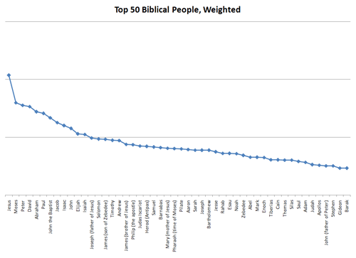
The top 50 biblical people weighted according to the above formula.

Twenty-three of the fifty people overlap between Sean’s list and my list. Let’s look at the ones that don’t overlap:

On My List On Sean’s List
John the Baptist Joshua
Joseph (father of Jesus) Hezekiah
James (son of Zebedee) Josiah
Andrew Ahaz
James (brother of Jesus) Simeon
Philip (the apostle) Manasseh
Judas Iscariot Uzziah
Herod (Antipas) Jeremiah
Barnabas Zedok
Mary (mother of Jesus) Eleazar
Pilate Balaam
Sarah Joab
Bartholomew Nebuchadnezzar
Rahab Dan
Zebedee Levi
Abel Nun
Mark Phinehas
Enoch Sihon
Tiberias Merari
Cain Absalom
Thomas Reuben
Silas Benjamin
Apollos Issachar
John (father of Peter) Naphtali
Stephen Asher
Gideon Ephraim
Barak Zebulun

I can’t honestly say that either of these lists is superior overall. I like parts of my list better than Sean’s and parts of his better than mine.

Here’s the raw data (Excel 2007 file) if you want to look at it in more detail.

New Feature: Jerusalem Map Overlays

March 28th, 2007

Download a KML for Google Earth containing map overlays for Jerusalem, both ancient and modern.

A partially transparent printed map overlays Jerusalem in Google Earth.

Don’t forget to adjust the transparency of the maps and turn on the Google Earth terrain layer to get a strong sense of the topography.

Twelve maps are there now—six of ancient Jerusalem and six of modern Jerusalem. They’re of varying accuracy, especially the ones of ancient Jerusalem.

All the maps come from the David Rumsey Historical Map Collection, an amazing website with thousands of maps, all available under a Creative Commons license, though a slightly different flavor from the one on the rest of this site. Please observe the licensing restrictions for the map images.

More overlays may be on the way from other sources depending on whether I can get permission from the copyright holders to use them. I have to say that I’m a big fan of Creative Commons.

I first heard about David Rumsey from O’Reilly Radar.

Google Lit Trips

March 27th, 2007

My brother points me to GoogleLitTrips.com, a site with a similar mission to this one, except they map the places in classic works of literature instead of the Bible. They’ve done six books so far.

The most visually satisfying of the KMLs, in my opinion, is the one mapping the trip from Oklahoma to California for The Grapes of Wrath:

A Google Earth screenshot shows the Joads’ trip.

Click “9-12” in the banner at the top of the site to get to the list of books. (It took me awhile to figure it out.) Why couldn’t we have had Google Earth when I was an English major?